13.09.050 Public access.
A. Except as provided in subsection B of this section, shoreline substantial developments and shoreline conditional uses shall provide for safe and convenient public access to and along the shoreline where any of the following conditions are present:
1. The development is proposed by a public entity or on public lands;
2. The nature of the proposed use, activity or development will likely result in an increased demand for public access to the shoreline;
3. The proposed use, activity or development is not a water-oriented or other preferred shoreline use, activity or development under the Act, such as a non-water-oriented commercial or industrial use; or
4. The proposed use, activity or development will interfere with the public use, activity and enjoyment of shoreline areas or water bodies subject to the public trust doctrine.
B. An applicant shall not be required to provide public access where the city determines that one or more of the following conditions apply:
1. Proposed use, activity or development only involves the construction of four or fewer single-family or multifamily dwellings;
2. The proposed use, activity or development only involves agricultural activities;
3. The nature of the use, activity or development or the characteristics of the site make public access requirements inappropriate due to health, safety or environmental hazards. The proponent shall carry the burden to demonstrate by substantial evidence the existence of unavoidable or unmitigatable threats or hazards to public health, safety or the environment that would be created or exacerbated by public access upon the site;
4. The proposed use, activity or development has security requirements that are not feasible to address through the application of alternative design features or other measures;
5. The economic cost of providing for public access upon the site is unreasonably disproportionate to the total long-term economic value of the proposed use, activity or development. For the purposes of this section “unreasonable and disproportionate” means that the economic cost of public access would add more than 20 percent to the total project cost;1
6. Significant and unmitigable harm to the shoreline environment would be likely to result from an increase, expansion or extension of public access upon the site;
7. The city’s adopted parks and recreation plans including the parks and recreation open space action plan (PROSAP) does not indicate a need for a trail or access at the property, and reasonably safe and convenient public access to the shoreline exists within one-quarter mile (1,320 feet) of the site; provided, that this exception shall not apply if the total frontage of the site along the shoreline is 1,320 feet or greater in dimension;
8. Public access has reasonable potential to threaten or harm the natural functions and native characteristics of the shoreline;
9. The site is within or part of an overall development, a binding site plan or a planned unit development which has previously provided public access through other application processes; or
10. Public access is deemed detrimental to threatened and/or endangered species under the Endangered Species Act. The shoreline administrator shall consult with governmental agencies or authorities with jurisdiction when making this determination.
C. Except for detached single-family residential dwellings and detached residential subdivisions, shoreline development proposals that have the potential to impact public views of the shoreline from public land or substantial numbers of residences shall demonstrate protection of shoreline views through implementation of the following standards:
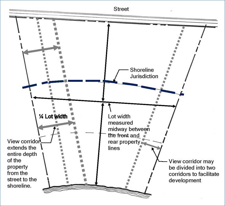
1. The implementation of view corridor(s) a minimum of one-fourth of the property width. These view corridors shall be maintained free of structures, parking and driveways for the entire depth of the property from the street to the shoreline. The view corridors may be divided into two corridors to facilitate development of the property. “Property width” shall mean the dimension across a point midway between the front and rear property lines as measured parallel or as near thereto as practical to the course of that portion of the ordinary high water mark nearest the property. See Figure 13.09.050-1 for an illustration of view corridors.
2. Special setbacks established from adjacent structures.
3. Upper story setbacks eight-foot minimum at second floors.
Fig. 13.09.050-1. Illustration of View Corridors
D. Proponents shall include within their shoreline applications an evaluation of a proposed use, activity or development’s likely adverse impact upon current public access and future demands for access upon the site. Such evaluation shall consider potential alternatives and mitigation measures to further the policies of this SMP and the provisions of this section.
E. In order to maintain public access, the city shall not vacate such public rights-of-way or easements. Public access provided by public street ends, public utilities and rights-of-way shall not be diminished by a proposed use, activity or development.
F. Where public access routes terminate, connections shall be made with the nearest public street unless determined by the shoreline administrator to be infeasible.
G. The following standards shall apply to all public access:
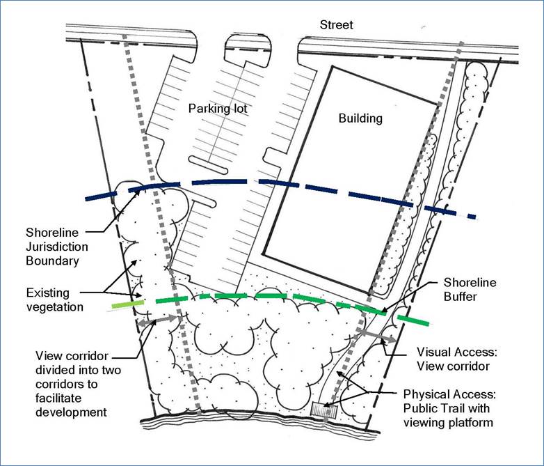
1. Types of Access. Applicants required to provide, or who voluntarily provide, shoreline public access shall provide for both physical and visual access, unless due to dangerous or unsafe site conditions only visual access is feasible. Examples are listed in subsections (G)(2) and (G)(3) of this section.
2. Visual Access. Visual public access may consist of view corridors, viewpoints, or other means of visual approach to public waters.
3. Physical Access. Physical public access may consist of a dedication of land or easement and a physical improvement in the form of a walkway, trail, bikeway, park, boat or canoe and kayak launching ramp, dock area, view platform, or other area serving as a means of physical approach to public waters. Perpendicular trails with limited shoreline access points are an acceptable form of public access provided the PROSAP does not identify a particular alignment or connection for the subject property.
4. Illustration of Visual and Physical Access. Figure 13.09.050-2 illustrates example visual and physical access, including required view corridors.
Fig. 13.09.050-2. Public Access Illustration, Visual and Physical
H. Off-Site Public Access. Off-site public access may:
1. Be permitted by the city where it results in an equal or greater public benefit than on-site public access, or when on-site limitations of security, environment, or feasibility are present;
2. Be visual or physical in nature;
3. Include, but is not limited to, enhancing a nearby public property (e.g., existing public recreation site; existing public access; road, street or alley abutting a body of water; or similar) in accordance with city standards;
4. Involve providing, improving or enhancing public access on another property under the control of the proponent or a governmental body or agency; or
5. Include another equivalent measure as approved by the shoreline administrator.
I. Shared community access may be allowed if there is no existing or planned public access along the shoreline as determined by a review of the parks, recreation and open space action program. Where provided, community access is subject to all applicable development standards of this section.
J. Public access facilities shall accommodate persons with disabilities unless determined infeasible by the shoreline administrator.
K. Public access facilities required for an approved or permitted use, activity or development shall be completed prior to occupancy and use of the site or operation of the activity.
L. Where public access is to be provided by dedication of public access easements along the OHWM, the minimum width of such easements shall be as follows:
1. Regional trails: 16 feet total width with 12 feet of paved travel way and two two-foot-wide gravel shoulders and clear zones. The standards may be adjusted by the shoreline administrator to avoid adverse critical area impacts.
2. City trails: 12 feet total width accommodating 10 feet of travel way and a total of two feet of gravel shoulders and clear zones, or as otherwise approved by the shoreline administrator to match existing connecting city trails.
3. The public easements required pursuant to this section, for the purpose of providing access across or through the site to the OHWM, shall be improved and maintained by the property owner to provide for reasonable and safe public access to the OHWM.
M. Public access easements, trails, walkways, corridors, and other public access facilities may encroach upon any buffers or setbacks stipulated within Chapter 13.13 BMC, Critical Areas in Shoreline Jurisdiction, or under other provisions of this SMP; provided, that no net loss of ecological function is achieved.
N. Signage to be approved by the administrator shall be conspicuously installed along public access easements, trails, walkways, corridors, and other facilities to indicate the public’s right of use and the hours of operation. The proponent shall bear the responsibility for establishing and maintaining such signs.
O. The administrator may require the proponent to post signage restricting or controlling the public’s access to specific shoreline areas. The proponent shall bear the responsibility for establishing and maintaining such signage.
P. Public access does not include the right to enter upon or cross private property, except on dedicated public rights-of-way or easements or where development is specifically designed to accommodate public access. Public access facilities shall be compatible with adjacent private properties through the use of techniques to define the separation between public and private space, including but not limited to setbacks, screening materials, landscaping, and natural elements such as logs, vegetation, and elevation separations. The city may condition shoreline applications to reinforce the distinction between public and private space.
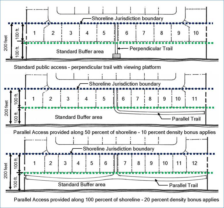
Q. Within the shoreline residential and high intensity environment designations, but excluding territory in the Bothell downtown subarea plan, the number of dwelling units within an attached residential development or the number of lots within a detached residential development may be increased within shoreline jurisdiction pursuant to Table 13.09.050-1 in exchange for providing a new publicly accessible trail placed on the subject property that parallels the shoreline water body, consistent with all of the following:
1. A general public access easement shall be recorded and located in the same location as the physical trail. The easement shall be a minimum of 25 feet wide and shall be permanently dedicated for public use and public access;
2. The public access easement shall be physically connected to a public right-of-way by a minimum 15-foot-wide public access easement;
3. The trail widths shall be constructed pursuant to subsection L of this section;
4. Trails shall be consistent with subsections J through P of this section; and
5. Density bonuses are not applicable in the downtown subarea plan.
Density bonus options are illustrated for example on Figure 13.09.050-3.
|
Type of Public Access |
SR and HI Residential Incentives |
|---|---|
|
Parallel trail comprising 50 percent to 75 percent of the shoreline length |
• 10 percent increase in the number of dwelling units or lots • Reduction of lot circle requirements up to 15 percent • Reduction of lot area by 20 percent • Should the applicant select to locate any additional lots authorized by this provision outside shoreline jurisdiction, the community development director may reduce the lot areas and lot circle dimensions of lots located outside shoreline jurisdiction to accommodate the additional lots, consistent with the applicable provisions of the Bothell Municipal Code |
|
Parallel trail comprising 76 to 100 percent of the shoreline length and the trail allows for future connections to adjoining properties |
• 20 percent increase in the number of dwelling units or lots • Reduction of lot circle requirements up to 30 percent • Reduction of lot area by 50 percent • Should the applicant select to locate any additional lots authorized by this provision outside shoreline jurisdiction, the community development director may reduce the lot areas and lot circle dimensions of lots located outside shoreline jurisdiction to the minimum necessary to accommodate the additional lots consistent with the applicable provisions of the Bothell Municipal Code |
Fig. 13.09.050-3. Density Bonus Study
(Ord. 2280 § 6, 2019; Ord. 2112 § 3 (Exh. C), 2013).