a. Hard Surfaces are non-vegetated surface areas which either prevent or retard the entry of water into the soil mantle as under natural conditions prior to development, and/or cause water to run off the surface in greater quantities or at an increased rate of flow from the flow present under natural conditions prior to development.
i. Common hard surfaces include, but are not limited to, roof tops, walkways, patios, driveways, parking lots, or storage areas, concrete or asphalt paving, gravel roads, packed earth materials, and other surfaces which similarly impede the natural infiltration of stormwater.
ii. Open, uncovered retention/detention facilities, engineered infiltration systems such as green roofs and porous paving, turf, landscaping and natural vegetation that infiltrate, reuse, or evapotranspirate rainwater shall not be considered as hard surfaces for the purposes of determining whether the thresholds for application of minimum requirements are exceeded, but shall be considered hard surfaces for the purposes of runoff modeling.
b. Hard Surface Coverage is the percentage of the total area, including setback areas, of a parcel that is covered by any hard surface.
2. Regulation.
a. The maximum hard surface coverage permitted shall be as determined in BMC 12.64.100, District Requirements.
b. All paved and landscaped areas shall incorporate best management practices to control stormwater as outlined in the City of Bothell Storm Water Design Manual and all development shall limit the amount of hard surface coverage to the minimum coverage necessary to accommodate the development.
B. Drainage Plan.A drainage plan shall be required for all development as required by title 18 of the BMC.
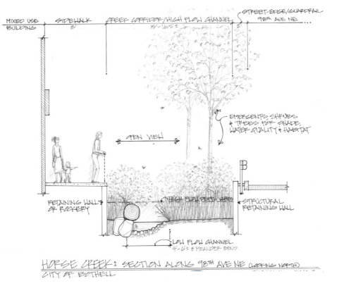
C. Horse Creek Daylighting Special Regulations.These regulations apply north of SR 522 within the Downtown Subarea to any proposed conversion of currently piped portions of Horse Creek to an open channel, a process known as “daylighting”; to the existing open channel of Horse Creek in this area, north of NE 188th Street; and to any proposed development adjacent to such open channels. The creek itself, the creek bed, associated riparian vegetation, in-stream features such as woody debris and rocks, any graded earth, retaining walls, rockeries or other structures containing the aforementioned elements, and any protective railings or other barriers shall together comprise the “daylighted creek corridor,” Figure 12.64.302.C illustrates a typical section through the envisioned daylighted creek corridor. These regulations apply in lieu of any conflicting critical areas regulations. Any portion of Horse Creek south of SR 522 shall be subject to the critical area regulations or the Shoreline Master Program regulations, whichever apply.
1. Daylighted Creek Corridor Width and Depth.The width and depth of the daylighted creek corridor in combination shall provide sufficient capacity to satisfy fish passage requirements and to accommodate historic and/or projected peak flows at maximum velocities and depths as determined by the public works director, while generally maintaining a width-to-depth ratio of approximately 3:1 or greater to avoid an unattractive canyon-like aspect and, subject to the limitations set forth in BMC 12.64.302(C)(2), to ensure adequate area within the corridor to sustain riparian vegetation on one or both sides of a low-flow channel which would run year-round.
2. Buffer Vegetation.No buffer vegetation shall be required outside the limits of the daylighted creek corridor; provided, that within the corridor, vegetation rendering shade, habitat and water quality functions including retention and biodegradation of pollutants shall be installed on one or both sides of the low-flow channel, which vegetation shall be selected, planted and maintained so as to survive inundation of roots, branches and/or foliage during high flow periods. Where, by virtue of limited available corridor width or other factors, these vegetation regulations conflict with fish passage requirements, vegetation shall be reduced to ensure adequate fish passage.
3. Roads, Driveways, Pedestrian Facilities, and Utilities.Roads, driveways, pedestrian facilities and utilities may cross and/or run directly alongside the daylighted creek corridor provided such facilities do not impede creek flows.
4. Public Open Space Credit.If the daylighted creek corridor includes any property which is not public right-of-way and which has development or redevelopment potential, the land area within the limits of the daylighted creek corridor on such property shall count towards satisfaction of the public open space requirements, as established in BMC 12.64.304, of a development on that property.
Fig. 12.64.302.C. Envisioned Daylighted Horse Creek Corridor, Typical Section